Byler and Cheatham Roads
Many of the early Indian trails crossing north Alabama were laid out to take advantage of the springs; the land divides between different watersheds, and the terrain. Many settlers, who came in to northwest Alabama from the Carolinas, Georgia, and Tennessee, called the Warrior Mountains home. Many of the families claimed the beauty of the hills and hollows for some 100 years – the early 1800’s through the early 1900’s. The United States government began buying the property from these settlers in the early 1900’s in order to establish a national forest in Lawrence and Winston Counties. Most of the early settlers were from similar hill country of the Appalachians; therefore, the low but rugged hills and mountainous land afforded them all the comforts of their old home places. Most of these early settlers, who sought the Bankhead National Forest region as home, were poor folks of Celtic (Scots, Irish) and Indian (Cherokee, Creek) descent. Many of the men, who were trappers, traders, or small farmers, were married to Indian women or intermarried with Indian families.
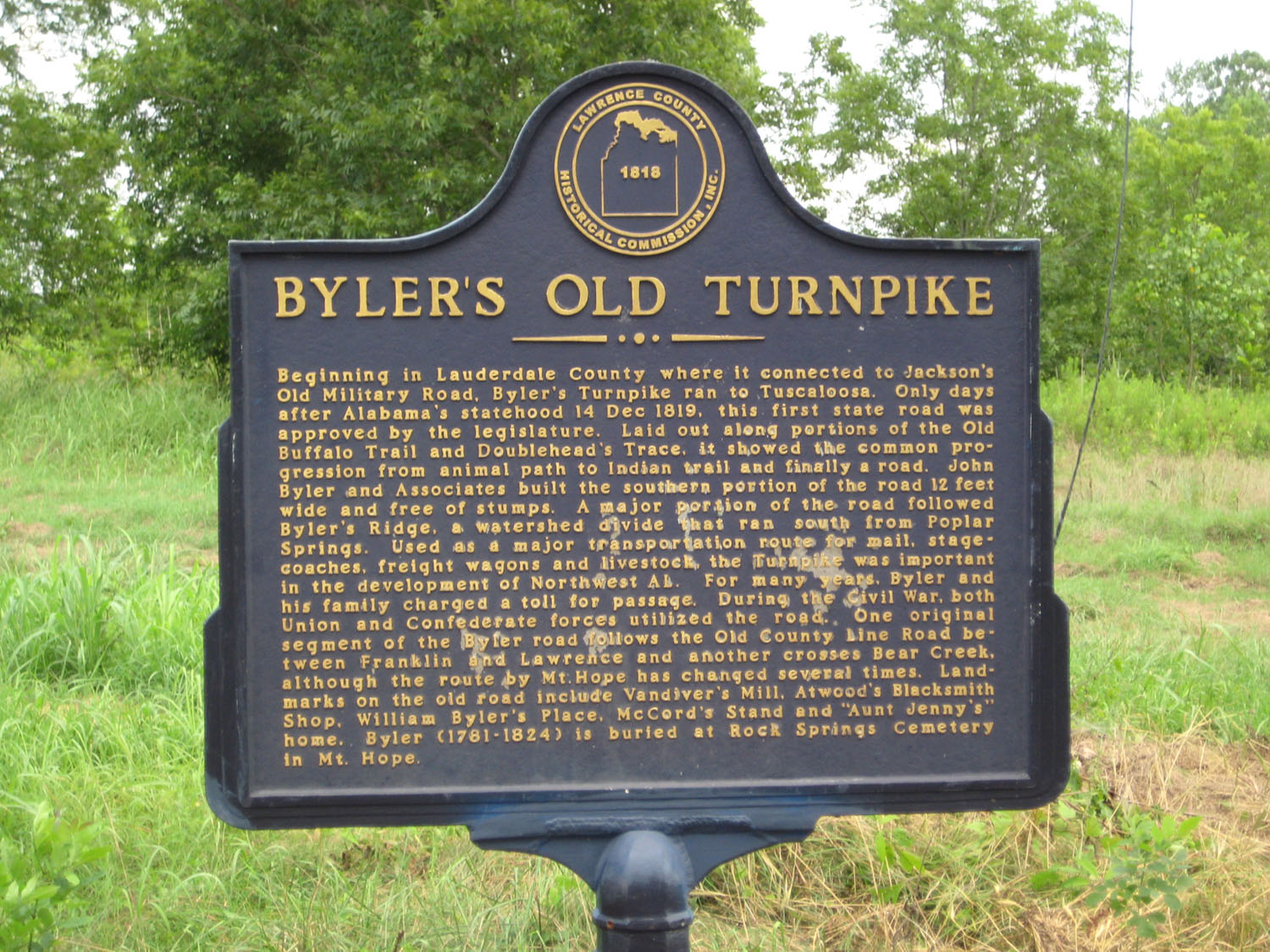
Byler Road Historic Marker
After the Turkey Town Treaty of 1816 took the Indian land in Franklin (Colbert), Lawrence, and Morgan Counties of north Alabama, the area was opened for settlement and hundreds of people rushed into the area to claim the prized land. Madison County had been established about 1806 and many of the first settlers coming overland by way of Huntsville probably crossed the Tennessee River by ferry. Four ferries, Rhodes Ferry and Brown’s Ferry from Limestone County; and, Bainbridge Ferry and Lamb’s Ferry from Lauderdale County, probably carried people and supplies to the south side of the Tennessee River to the lands opened for settlement. Brown’s Ferry, which was just east of Brown’s Island, crossed the river between Mallard and Fox's Creek. The Brown's Ferry Road ran from present-day Huntsville to Courtland, Alabama. Rhodes Ferry crossed the river from Limestone County to present-day Decatur. The old Jasper Road crossed at Rhodes Ferry and ran from Nashville to Tuscaloosa. Bainbridge Ferry came from Jackson's Military Road to the south side of the Tennessee River. Bainbridge Ferry became the crossing of Byler Road. Lamb’s Ferry crossed the river from now present day Rogersville to a place some three to five miles west of Spring Creek in Lawrence County. Lamb’s Ferry, located at the lower end of Elk River Shoals, was the crossing of a major north-south route from Pulaski, Tennessee to Tuscaloosa, Alabama, known in Indian days as the Sipsie Trail.

Jackson's Military Road Historic Marker
Prior to the late 1830’s probably few settlers came from the east through the Cherokee Nation unless they were Cherokee mixed-bloods or connected to the Cherokee through marriage. Until the late 1830’s, the Cherokee Nation controlled large sections of land from the eastern edge of Morgan County in Alabama, through the upper northwestern third of Georgia, and into the southeastern third of Tennessee. After the Indian removal in 1838, all Indian lands in Tennessee, Georgia, and Alabama were opened for settlement.
With the invention of the cotton gin in 1793, cotton became the “Agricultural King” not only to the Cherokee people, but to the hundreds of settlers who would quickly claim the Tennessee Valley regions of north Alabama. However, the Warrior Mountains to the south of the river had an attraction for the Appalachian mixed-blood Indian descendants which they could not resist. All of my early ancestors, though poor by means of worldly treasures, found that early spot where peace, beauty, and tranquility abounds both in life and death in the eternal land of the “Warrior Mountains.
Byler Road
The Byler Road ran through the western portion of the Warrior Mountains from the Tennessee River to Tuscaloosa. The Byler Road was one of the first roads authorized by the Alabama State Legislature. The road was approved two days after Alabama was admitted into the Union of the United States of America on December 14, 1819. The road was named after John Byler, who is buried in Rock Springs Cemetery at Mt. Hope in Lawrence County, Alabama.
The road ran from Bainbridge Ferry on the Tennessee River, across the western border of Lawrence County, and into the Warrior Mountains of present day Bankhead National Forest. The road went southward to the falls of the Tuscaloosa River and basically ran the divide between the Tombigbee and Warrior River drainages. The road followed the basic route of the Old Buffalo Trail, which was a north-south route for the Creeks and Choctaws to the French Lick (Nashville).
The mountainous part of the route between the upper portion of Bear Creek and Sipsey River drainages of Lawrence County was along the same route laid out by Captain Edmund Pendleton Gaines on July 31, 1807. The area was part of the Cherokee and Chickasaw territories. According to an early map of Lawrence County, William McCain, son-in-law of John Byler, ran a toll gate on the Byler Road near its junction with the Northwest Road. The toll gate was located in the Southeast quarter of Section 18 of Township 8 South and Range 9 West.
The Moulton Fork of the Byler Road ran from Moulton, skirting the edge of the mountains through Youngtown, and up to the mountain at McClung Gap. The two Byler Roads joined at a site known as the 66 mile tree which was located about one-half mile west of the junction of the High Town Path and the Moulton Fork in the southwest one-quarter of Section 33 of Township 7 South and Range 9 West. The 66 mile tree was thought to be a designated tree at the forks of the two roads. The total distance, from the beginning of the Byler Road of the Byler Road at Bainbridge Ferry on the Tennessee River, and the beginning of the Byler Road Fork beginning at Moulton, to their junction on top of Continental Divide south of Mt. Hope, was supposedly marked on a tree designating the 66 miles of the Byler Roads north from that point.
Since prehistoric Indian times, the portion of Byler Road between Poplar Springs Cemetery and Aunt Jenny Brook’s home place was utilized as a trail or route from prehistoric Indian times. This particular portion of the Byler Road was previously designated using various names; the High Town Path, the Old Buffalo Trail, and Doublehead's Trace. The road was also the tribal boundary of the Creeks, Cherokees, and Chickasaws.
During the Civil War, Union troops of Northern Aggression under the command of Colonel Abel Streight were attacked on the Byler Road near Aunt Jenny’s place. In addition, Union General G.M. Dodge’s scouting part utilized the Byler Road in the Spring of 1864. Later in March, 1865, one division of Union General J. H. Wilson’s cavalry of 13,480 horseman passed down the Byler Road in route to Tuscaloosa and the Battle of Selma. General Winslow's division passed along the Byler Road through Lawrence County and stayed the night at David Hubbard’s Plantation located at Kinlock.

Major General Grenville Mellen Dodge
4/12/1831-1/3/1916
Cheatham Road
An Indian route known as the Sipsie Trail, the Cheatham’s Turn-Pike, and the Wilderness Parkway is a road through the Warrior Mountains which has been traveled by many people. However, without a doubt, the most historical of all too ever use the road through the middle of Bankhead Forest was Wyatt Cheatham. Today, the road is known as state highway 33.
Due to a 1824 Act of the Alabama Legislature, Wyatt Cheatham was authorized to upgrade the trail and build the Cheatham Road. The actual upgrade of the road began seven miles south of Moulton and is the approximate location of the existing junction of Leola road and highway 33. The roadway was to be cleared 18 feet wide with 12 feet of roadway clear of stumps.
The old horse and wagon road through the mountains is still visible in many places. The original road ascended Wren Mountain along the west side of the valley, west of present day highway 33. The old road reaches the mountain top some 200 yards east of the junction of Ridge Road with highway 33. South from the Ridge Road on highway 33, old roadbeds exhibit existing signs of the original roadway and are adjacent to the edges of the Wilderness Parkway.
According to the Annuals of Northwest Alabama by Donald and Wynelle Dodd, Cheatham was directed by the Act to build the road toward Tuscaloosa. The point of beginning would be the approximate junction of the Leola Road with state highway 33, presently known as the “Wilderness Parkway.” This point would be the same as the High Town Path’s junction with the Brushy-Sipsey Dividing ridge.
It appears that Wyatt Cheatham had assistance in his appointment over the construction of the roadway. Joseph Coe, who was Lawrence County’s State legislative representative, was obviously a good friend to Wyatt Cheatham. The Old Land Records of Lawrence County by Margaret Cowan, indicate that Joseph Coe (originally from Tennessee) had entered land some three miles south of Courtland in Section 7 of Township 5 South, Range 7 West on September 11, 1818. Cowart states that Wyatt Cheatham originally entered 160 acres of land at Wren and 160 acres near Spivey Gap on September 12, 1818. He also entered an additional 160 acres near Wren after moving to Winston County. On February 12, 1825, Wyatt Cheatham and Joseph Coe jointly entered 80 acres of land in Winston County where the (their) road crossed Clear Creek in Section 30 of Township 11 South, Range 8 West, according to the Dodd. Earlier on January 26, 1825, Wyatt Cheatham had entered 80 acres near the same location in Winston County.
Wyatt Cheatham is listed in the 1820 Census of Lawrence County, but is not found after that time in the county census records. However, Wyatt again entered an additional 160 acres of land at Wren on September 28, 1831, some six years after entering land in Winston County. According to the Lawrence County Census of 1820, Wyatt Cheatham and wife had nine boys under age 21, and two girls under age 21, along with the ownership of two slaves. In the 1830 Census of Walker County, Wyatt Cheatham is listed as being 55 years old with six boys under age 20, 3 boys over age 20, and one female under age 20, and one female over 20, and in addition, two slaves. It is obvious that Cheatham lost a daughter or his wife between 1820 and 1830. Again in the 1850 Census of Winston County, Wyatt Cheatham is listed as being a 72 year old native of Virginia. At the time of the census, Wyatt lived with Lavina, 29; George, 16; Francis, 12; Thomas, 11; and an infant girl, Elizabeth, 1. All are listed as being born in Alabama.
According to a January 13, 1826, statement made by the Dodds, and election precinct was approved at the home of Wyatt Cheatham on Clear Creek where said Cheatham’s Turn-Pike crossed the sand. In 1828, Wyatt Cheatham obtained a license to sell liquors at his place at the Clear Creek crossing. Wyatt and his son, Wyatt D. Cheatham, renewed their liquor license for $10 in 1833. Cheatham served in the War of 1812 as a sergeant in John A. Allen’s Madison County Company. After the war, he moved to Wren where he entered a total of some 320 acres of land. Wyatt Cheatham had a strong alliance with Andrew Jackson.
It appears from historical records that Wyatt Cheatham moved from Madison County to live at Wren in Lawrence County from 1818 until he was authorized to build the Cheatham Road. By 1825, he had moved to Winston County and entered land at the Clear Creek Crossing of his road. In later years, he profited in trade from folks who traveled along his road and stopped by his tavern on Clear Creek.
The route through the middle of Bankhead Forest was known for many years at the Cheatham Road. The road officially changed to Wilderness Parkway after the establishment of the Sipsey Wilderness Area. The present day route of highway 33 going to the top of Wren Mountain is in its third location since the original road was built.
The Cheatham Road (which later became highway 33) and the Wilderness Parkway was improved and parts were re-routed up the Wren Mountain in the late 1920’s. The road was eventually paved and rerouted again during the late 1940’s. Many portions of the original Cheatham wagon road are still visible today along highway 33 South of Wren.
Scott Cheatham here in northern Michigan, my GrandMother was Pearl, she was Cherokee. My Father's name was Neal, his father was Clifford.
ReplyDelete