Waterfalls of the Warrior Mountains
The overlying layer of sandstone in the Warrior Mountains has given away to erosion, thus creating some 400 miles of rugged sand rock walled canyons. Plunging into these canyons are steams and creeks creating hundreds of waterfalls. The winter and spring seasons are the most ideal times to hike into the canyons of the Warrior Mountains to view the many spectacular waterfalls hidden deep within the forest. Most of our waterfalls are seasonal but during rainy seasons, these waterfalls are perhaps the most exquisite waterfalls and their surrounding scenery found anywhere in the world.
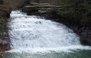
Kinlock Falls
In addition to the waterfalls, many springs with clear fresh water flowing from limestone crevasses are found throughout the Warrior Mountains. Many of these springs erupt at the edge of the Moulton Valley where the land abruptly rises from flat land at some 650 feet in elevation to the rim of the hills at some 1,000 feet above mean sea level, thus creating the Continental Divide which separates the waters in north-south directions. South of the rim, which creates the back bone of North Alabama, has streams of water flowing south eventually into Sipsey River, to the Black Warrior River, and then joins with the Tombigbee River onward to Mobile Bay. On the northern slopes of the divide, all the runoff eventually flows northerly into the Tennessee River, the Ohio River, and the mighty Mississippi River.
With thousands of years of erosion caused by the runoff of many rainfalls, the valleys of Bankhead have been cut deep through the massive sandstone formations overlying thick layers of limestone. At the edge of the limestone outcroppings are numerous caves and springs which once provided drinking water to native wildlife, Indians, and early settlers who made Bankhead their home. Many sandstone bluff shelters are found throughout the Warrior Mountains. The shelters and overhanging rock ledges provided many early Indian inhabitants a home and protection from the elements. Probably the most well-known of these protective sites is the Kinlock Rock Shelter located in the southwestern corner of Lawrence County, Alabama.
Over the centuries, the sandstone layers of overlying rock in the Warrior Mountains were eroded away creating the canyons and gorges in the Bankhead National Forest. These particular canyons are the sites of some one thousand waterfalls; thus, this area is known as the “Land of a Thousand Waterfalls.” The majority of the falls are seasonal and are most beautiful during the winter and spring months. Many of the deep gorges in Bankhead range from 60 to 100 feet high with the highest waterfalls some 70 to 100 feet in height. The following is a brief listing of some of the most beautiful waterfalls in the Warrior Mountains. Remember, thousands of waterfalls can be found all over the Warrior Mountains and provide wonderful experiences for those who explore her canyons and gorges.
Kinlock Falls – Kinlock is probably the best known waterfall or cascading waterfall in Bankhead. Water flows over Kinlock for the entire year, but the many winter rains determine the waterfall’s ultimate crescendo during the spring, thus creating a white cascade on a canvas of green leaves. Kinlock Falls is located on Hubbard Creek. To locate the falls, go north at the west end of the Cranal Road. Prior to reaching the Hubbard Creek Bridge, the falls can be discovered some 20 yards to the right of the road.
South Caney Creek Falls –The two beautiful Caney Falls are the most spectacular in the forest with each having a vertical drop of some 30 feet into a huge pool of turquoise water. These are two of the largest waterfalls in the forest when comparing greatest volume of water. After crossing Sipsey River going south, you must turn west off Highway 33 onto Highway 2. Travel west on Highway 2 for 3.8 miles to a USFS road. There is a steel closure on the right and/or north of the road. It is approximately one miles out the FS road to the upper falls. Go downstream less than a mile to the lower falls which is my favorite.
Turkey Foot Creek Falls – Two beautiful waterfalls are located in close proximity to each other on Turkey Foot Creek. At the Sipsey River Recreation Area on the Cranal Road, travel west along Turkey Foot Creek which enters Sipsey River a few feet of the north side of the west bridge abutment. As you walk up the creek, look at the Indian mortar and shelter under the north bluff. Within a half-mile west up Turkey Foot Creek from the Sipsey River Bridge, you will see the first beautiful waterfall.
Collier Creek Falls – Collier Falls are located just east of the Grayson Sawmill lumber yard. The waterfall was the site of a large gristmill. Two huge stone columns approximately 20 feet high held the waterwheel and are still presently intact. From the Grayson lumber yard, travel east about three-fourths of a mile and follow the hollow to the beautiful falls that plunge into a narrow box canyon.
Sow Creek Falls – Sow Creek flows off a rock shelter that completely circles the waterfall. You can stand in the shelter 20 feet behind the waterfall. The fall drops vertically approximately 40 feet into a beautiful pool of water. This waterfall is approximately two miles upstream from Brushy Creek Bridge located on Hickory Grove Road. The creek flows in from the west, thus falls are about 300 yards from Brushy Creek. Drive toward Moreland from Brushy Creek Bridge approximately one and a half miles and turn north on the gravel log road. Finally, one must walk north and travel into the hollow which will also lead to the falls.
Holmes Chapel Falls – The falls are located about one-fourth mile west of Rush Creek Bridge on the Mt. Olive Road. There are two routes leading to the falls. One route is the branch that leads to the falls enters Rush Creek on the southwest side of the bridge. Another route entails traveling one-fourth mile west of the bridge and stop at the first log road to the southwest. The falls are located about 200 yards south of the Mt. Olive Road.
Parker Falls – Parker Falls are located in a beautiful canyon through which the Parker Branch flows. The falls, which are stair steps, are absolutely beautiful. Parker Falls are in the Sipsey Wilderness near the point where the Winston and Lawrence County lines cross Parker Branch. The upstream portion of Parker Canyon is rugged, but below the falls lies one of the most spectacular old growth found anywhere in Bankhead.
Indian Tomb Hollow Falls – Three beautiful, but small waterfalls, are located in the southwestern end of Indian Tomb Hollow. These falls are seasonal but are worth the two mile hike up the canyon.
Quillan Creek Cascades – Quillan Creek flows through a rugged, extremely narrow canyon which has high vertical sandstone walls covered with eastern hemlock trees. One could easily throw a rock from one side of the canyon to the other. Near the middle of Quillian Creek Canyon are a beautiful set of cascades flowing through solid sandstone troughs. On the upstream side of the cascades is an Indian rock shelter.
Conclusion
The above mentioned waterfalls are only a small fraction of the falls within the canyons of Bankhead National Forest. Hundreds of small waterfalls plunge to the canyon floors, some ranging as high as 100 feet. During the wet season which usually occurs during winter and early spring, you need explore many of the waterfalls crashing into the canyons of the Warrior Mountains. These falls can bring peace, beauty, and serenity to the few who behold the eloquence of the “Land of a Thousand Waterfalls”.
Thank you, Butch, for this article. Having grown up in and around the forest, I have had the privilige of visiting the majority of these falls. There are still a couple on this list I will have to check out now, as well as show newcomers to the area the beauty and wonder of our Bankhead Forest. Shea DeVaney
ReplyDeleteButch could i get your email? You helped us with our genealogy work to get our cards my daughter is the new Miss Indian Alabama and she would like to help get the Indian education program u have used in Lawrence co established in Colbert Franklin and Lauderdale. Any help appreciated
ReplyDeleteThanks Philip Cole
colphilip@aol.com
This comment has been removed by the author.
ReplyDeleteThis comment has been removed by the author.
DeleteI have just visited Sow Creek Falls. It was beautiful and well worth the hike. I took pictures and would love to submit one for posting. I couldn't find any online. I was told that Sow is short for it's Native American name. Is that true?
ReplyDeleteI have just visited Sow Creek Falls. It was beautiful and well worth the hike. I took pictures and would love to submit one for posting. I couldn't find any online. I was told that Sow is short for it's Native American name. Is that true?
ReplyDeleteI've never heard it called Sow Creek. Of course, that doesn't mean much. Often times branches, creeks, and falls are refereed to by different names at different times. The old timers call them "South Falls". In recent times I have heard the falls referred too as Sougahoagdee Falls. They are truly beautiful whatever the name.
ReplyDelete