Saturday, November 12, 2011

Indian Place Names of Warrior Mountains

Indian Place Names

Several places in the Warrior Mountains and Tennessee Valley of northwest Alabama are known by their original American Indian names and are part of our local heritage.  In the following, some of local Indian site names are identified as part of our historic and cultural landscape.  Army officer Edmund Pendelton Gaines first recorded many of the original Indian locations during his survey of Gaines Trace from Melton's Bluff to Cotton Gin Port in December 1807 and January 1808.  During this time, the territory he was surveying was Indian country and their claims had not been taken by treaty.  Edmund was the brother of General George Strother Gaines, and he married Barbara Blount, the daughter of the Governor of Southwest Territory William Blount.  In the early 1800's, the Southwest Territory was all the land south of the Ohio River and west of the Appalachian Mountains.

General Edmund Pendleton Gaines March 20, 1777-June 6, 1849 


Alabama:  Alabama, Muskogee for thicket clearers, was a member of the Creek Confederacy and originally called the Alibamos.  Two sub-tribes the Creek people moved to the Big Thicket in east Texas around the 1780's and are known today as the Alabama-Coushatta.  The Alabama lived at the junction of the Coosa and Tallapoosa Rivers in the State of Alabama.  The Coushatta lived along the Tennessee River in north Alabama.  The two tribes eventually united in east Texas, but were considered to related and members of the Creek Nation in the State of Alabama.  

Big Head Spring:  This large spring was located in the northern portion of Lawrence County, Alabama and was beginning of Spring Creek which is just north of present-day Courtland, Alabama.  During the Wheeler Basin studies, an ancient Folsom point was found at the spring which was later flooded by the backwaters of Wheeler Lake.  In addition, Mr. Rayford Hyatt found three Clovis points on an island adjacent to and north of the spring.  The finds of paleo points indicate a long term occupation of the area in excess of 10,000 years.

Big Nance Creek:  The creek that flows north through center of Lawrence County, Alabama and empties into the Tennessee River less than one-fourth mile west of Wheeler Dam was originally recorded as Path Killer's Creek by Captain Edmund Pendelton Gaines on December 27, 1807.  The creek was later changed to Big Nance Creek after Doublehead's sister Nancy moved to Shoal Town and lived near the mouth of the creek. 

Black Warriors' Path:  This Indian trail became a post route known as Mitchell Trace after the building of Fort Mitchell in 1811 in Russell County, Alabama.  The fort was named after Indian agent David Brady Mitchell and the route connected Fort Mitchell to Fort Hampton in Limestone County, Alabama.  The route came from St. Augustine, Florida and followed the corridor of highway 280 just east of Birmingham, Alabama and crossed the Tennessee River near Melton's Bluff in Lawrence County, Alabama, through Columbia, Tennessee and then to the Big Lick or French Lick (Nashville).  This was the route used by General John Coffee to destroy Black Warrior Town near the present-day Town of Sipsey.   Black Warriors' Path was first recorded on Alabama maps by John Melish in 1813 and 1814.

Black Warrior Wildlife Management Area:  This area is located in Lawrence and Winston Counties of north Alabama, and was named in honor of the Creek Chief Tuscaloosa, which is translated to mean Black Warrior.  The forest was originally called the Black Warrior Forest, but later changed to honor a white politician.   The management area is also in the upper drainage of the Warrior River. 

Browns Creek:  Three Browns Creeks flow through north Alabama: 1) Browns Creek near Guntersville, Alabama; 2) Browns Creek beginning at Lindsey Hall in Bankhead Forest and runs into Brushy Creek prior to entering Lewis Smith Lake; and 3), Browns Creek in the extreme southwestern corner of Bankhead National Forest near Rocky Plains in Walker County, Alabama.  All these creeks are named in honor of the Brown Cherokee family.

Brown's Ferry:  The ferry was in Lawrence County, Alabama at the crossing of the Brown's Ferry Road from Huntsville to Courtland, Alabama.  There was also another Cherokee owned Brown's Ferry near Chattanooga, Tennessee.  The north Alabama ferry was originally operated by the Cherokee family of John Brown and historically recorded as being used as early as November 1813 by local Cherokee Cuttyatoy.  John Brown's daughter Patsy married Captain John D. Chisholm who acted as a attorney for Chickamauga Chief Doublehead who lived at Doublehead's Town at Brown's Ferry.  Betsy, another daughter of John Brown, married a Cox and for a short period the ferry was called Cox's Ferry, but it later reverted back to Brown's Ferry. 

Browns Spring:  This spring was located about one-half mile west of the old Jasper Road near the Inmanfield Road in the north part of Winston County, Alabama and was at the site of the original Looney's Tavern.  It was named after members of the Brown Cherokee Indian family and in the early days used as a gathering place for locals.  The famous meeting concerning the Free State of Winston took place near Browns Spring at Looney's Tavern.  Bill Looney, who led a group of Union soldiers, was also known as Black Fox and was thought to be a descendant of Chief Black Fox's daughter who married a Looney.  In 1890, my great grandfather Sidney Walker was shot at Browns Spring and died three days later.

Buzzard Roost Spring:  The spring, which is just west of the Town of Cherokee in Colbert County, Alabama, was near the home of Chickasaw Chief Levi Colbert-Itawamba Mingo.  He contracted Kilpatrick Carter to build him a fine home at the site, but Carter fell in love with Levi's daughter and married her; therefore, Levi gave the home at Buzzard Roost to his daughter.  Later Carter built his father-in-law Levi another house at Cotton Gin Port on the Tombigbee River.  On a trip to Washington, Levi stopped at his daughter's house at Buzzard Roost Spring where he died.

Chake Thlocko:  This was the crossings of the Tennessee River along the Muscle Shoals, and was translated as the Great Crossing Place or the Big Ford.  Several Indian trails crossed the river at Chake Thlocko:  Natchez Trace (Colbert's Ferry), Doublehead's Trace (Blue Water Ferry), Sipsie Trail (Lamb's Ferry), Black Warriors' Path (river crossing near Melton's Bluff), Browns Ferry Road (Browns Ferry), and Old Jasper Road (Rhodes Ferry).

Chickamauga:  This was the name of the Indian confederacy that operated in north Alabama under the leadership of Chickamauga Chief Doublehead.  The Chickamauga were made up of members of different tribes and included the Lower Cherokee, Upper Creek, Chickasaw, Shawnee, Delaware, and Yuchi.

Chickasaw Island:  This island is in the Tennessee River south of Huntsville, Alabama and was recognized as Chickasaw land in the Chickasaw Boundary Treaty of January 10, 1786.  The Cherokee actually forced the occupying Chickasaw from the area during the Battle of Chickasaw Old Fields in 1769.  

Colbert County:  The county is named in honor of the Chickasaw Colbert family.  James Logan Colbert of Scots origin moved to the Chickasaw Nation during his youth with traders.  He married three Chickasaw women and had two sons who became chiefs of the Chickasaw-George and Levi Colbert. 

Colbert's Ferry:  This was a government ferry established as part of a treaty with the Chickasaw of December 1801.  Colbert's Ferry was mentioned by Captain Edmund P. Gaines while surveying Gaines Trace in his field notes on January 8, 1807, as follows, "The mouth of 20 Mile-Creek is about 45 miles from Colbert's Ferry..."  Chickasaw George Colbert operated the ferry until his wife Tuskiahooto died in 1817.  After her death, George Colbert moved near present-day Tupelo, Mississippi with his other wife Saleechie, sister of Tuskiahooto.  Tuskiahooto and Saleechie were the daughters of Chickamauga Chief Doublehead; therefore, George was the double son-in-law of Doublehead.  According to the 1834 treaty with the Chickasaw, George Colbert made sure his reserve at Colbert's Ferry extended 60 yards south of the old home place to include the grave of his wife Tuskiahooto. 

Coldwater:  This was an early Chickamauga Indian village also known Oka Kapassa located at the junction of Coldwater Creek with the Tennessee River near Tuscumbia, Alabama.  The source of the creek was Big Spring in Tuscumbia.  The Indian village was destroyed by General James Robertson from Nashville, Tennessee in 1787 during the Chickamauga War.

Coosa Path or Muscle Shoals Path:  The Coosa Path or Muscle Shoals Path was a route from Ten Islands on the Coosa River to Dittos then to Tuscumbia Landing.  The path was recorded by Captain Edmund Pendleton Gaines while surveying the Gaines Trace from Melton's Bluff in Lawrence County, Alabama to Cotton Gin Port, Mississippi.  On the rainy day of December 29, 1807, Gaines wrote in his field notes "...cross Coosa Path, leading from the lower end of the Muscle Shoals to Coosa Town, Creek Nation, bearing about S. 26 degrees.  E. 70 miles distance."

Doublehead's Resort:  This Lawrence County, Alabama site is located near the mouth of Town Creek about one mile south of the Tennessee River and is named in honor of Chickamauga Chief Doublehead.

Doublehead's Trace:  This route was originally an old Chickasaw trail that was called the Old Buffalo Trail that led to the buffalo hunting grounds on the Cumberland River.  The trail was upgraded to a wagon road by Doublehead and the Cherokee.  The route was 100 miles in length from the mouth of Blue Water Creek to the Town of Franklin near Nashville, Tennessee and was called Doublehead's Trace.  The Cherokees actually built some 300 miles of wagon roads in their nation.

Doublehead's Spring:  Two different springs in north Alabama were known as Doublehead Spring.  One of the springs was located about two miles southwest of the Tennessee River at Doublehead's Village near Mhoontown north of the Town of Cherokee in Colbert County, Alabama.  The Doublehead Spring in Colbert County is shown on the 1839 LaTourette map.  The other spring was on the north bank of the Tennessee River in Shoal Town about 100 yards west of the mouth of Blue Water Creek in Lauderdale County, Alabama.  The Doublehead Spring near Blue Water Creek was shown on the 1816 Peel and Sannoner map.

Fox's Creek:  This creek begins on the northeast side of Lawrence County, Alabama and runs into the Tennessee River at the county lines of Morgan and Lawrence.  The creek is named in honor of the Principal Chief Black Fox of the Cherokee Nation.  Black Fox lived for a while near the site at a place known as Mouse Town or Moneetown.  Later his son Black Fox II lived and operated a trading post at the junction of Black Warriors' Path and Brown's Ferry Road about two miles west of the ferry.

Gourd's Island:  This island is now flooded by the backwaters of Wheeler Lake in the Tennessee River near the mouth of Elk River.  The island was named in honor of The Gourd, a Cherokee soldier who fought with General Andrew Jackson at the Battle of Horseshoe Bend in March 1814.  Gourd also founded Gourd's Settlement near present-day Courtland, Alabama that was recorded by Captain Gaines on December 28, 1807, as follows, "8th mile...At 119 chs. Cross the path which leads from Shoal Town, eastwardly, to Gourd's Settlement, about 3 miles distance".  

Gourd's Settlement:  This Cherokee village was first recorded by Captain Edmund Pendelton Gaines on December 28, 1807, as being located near Path Killer's Creek close to the present-day Town of Courtland, Alabama.  The settlement was at the junction of the South River Road and Sipsie Trail.  The Gourd along with two of the Melton brothers signed a letter on August 15, 1816, complaining about the killing of three Cherokees by James Burleson's family.  Gourd was also identified by Anne Newport Royall in her book, Letters from Alabama 1817 to 1822.

Gunter's Village:  The Town of Guntersville was named after Gunter's Landing in Marshall County, Alabama.  John Gunter, who was of Scots-Irish lineage, married a Cherokee woman by the name of Ghigoneli.  The Gunter family ran a trading post, powder mill, and a ferry across the Tennessee River. 

High Town Path:  This route was some 1,000 miles in length and ran from Old Charles Town, South Carolina to Chickasaw Bluffs on the Mississippi River near Memphis, Tennessee.  It is named in honor of the Indian village of High Town located near present-day Rome, Georgia.  The trail through north Alabama primarily follows the Tennessee Divide that separates the waters of the Tennessee and the waters that flows toward Mobile.

Indian Tomb Hollow:  This is the site of the Battle of Indian Tomb Hollow that was fought between the Creeks and the Chickasaws around 1780.  The area was the burial site for those that were killed in the battle.  The canyon is located in William B. Bankhead National Forest in Lawrence County, Alabama.  Indian Tomb Hollow has been set aside by the United States Forest Service and is considered a Traditional Cultural Property to be protected for future generations.

Kattygisky Creek:  The spelling for the creek was not exactly the same as Kattygisky, the Chickamauga chief that lived at Shoal Town near the mouth of the creek.  Kattygisky and Doublehead were friends and worked together in establishing Shoal Town.  The mouth of the small creek enters Town Creek from the west about a mile from the Tennessee River, and the creek is named in honor of the Cherokee named Kattygisky.  The creek originates in the northeast corner of Colbert County, Alabama and flows east prior to running into Town Creek across from Doublehead Resort.

Melton's Bluff:  This Cherokee town was named in honor of the Cherokee family of Irishman John Melton and his wife Ocuma, who was the sister of Doublehead.  John and Ocuma had several half blood children that lived at Melton's Bluff on the south bank of the Tennessee River in present-day Lawrence County, Alabama.  Some two years before John Melton died on June 7, 1815, he built a fine house on the north side of the river in Limestone County, Alabama below Fort Hampton.  The Melton's Bluff site was located at Tennessee River miles 287-288.  Captain Edmund P. Gaines started his survey of Gaines Trace on the south side of the river at Melton's Bluff on December 26, 1807.

Mhoontown: Doublehead's Spring and Doublehead's Village was located near here on the south side of the Tennessee River in Colbert County, Alabama.  According to the 1839 LaTourette map, the spring and village site appears to be about two miles southwest of the river .

Mouse Town:  This town was also known as Moneetown and was located at the mouth of Fox's Creek on the south side of the Tennessee River on the northern corner of Lawrence County and Morgan County line.  The old town site was recorded historically in the late 1800's by Colonel James Edmund Saunders as Moneetown and by General Edward Burleson of Texas as Mouse Town.  Mouse Town was at one time the home of Black Fox.

Natchez Trace:  This was a government route authorized by the treaty with the Chickasaws in December 1801 and ran from Nashville, Tennessee to Natchez, Mississippi.  The trace is named in honor of the Natchez Indians of Mississippi and runs through the northwest corner of Colbert County, Alabama.


Path Killer's Creek:  This creek was first recorded as Path Killer's Creek on December 7, 1807, by Captain Edmund Pendelton Gaines.  The creek was originally named in honor of Cherokee Chief Path Killer who was elected principal chief of the Cherokee Nation after the death of Black Fox.  Path Killer served as chief from 1811 to 1826.  The creek later became known as Big Nance Creek in Lawrence County, Alabama.

Shoal Town:  This Cherokee village was first recorded by Captain Edmund Pendelton Gaines on December 28, 1807.  The Cherokee town was located on Big Muscle Shoals some seven miles from its eastern end between Big Nance Creek, Town Creek, and Blue Water Creek.  Big Muscle Shoals was some 15 miles in length.  In 1793, the Creeks said that Doublehead and Kattygisky had established the village.  Doublehead's sister Nancy and his great nephew Tahlontuskee Benge lived at Shoal Town.  About 1802, Doublehead moved from Doublehead's Town at Browns Ferry to Shoal Town where he had a trading post at the mouth of Blue Water Creek.  He was living at Shoal Town when he was assassinated on Hiwassee River in Tennessee on August 9,1807.

Sipsey:  The river that flows into Lewis Smith Lake out of the William B. Bankhead National Forest portion of the Warrior Mountains is  known by the Indian name Sipsey which means poplar tree or some say cottonwood tree.  The Sipsey Wilderness Area was established in 1975 and will be preserved and protected for future generations to enjoy. 

Tennessee River:  The river was originally called the Hogohegee or River of the Cherokees.  The Cherokees controlled the vast territory that made up most of the drainage of the Tennessee River.

Town Creek:  This creek was originally called Shoal Town Creek, because the Cherokee village of Shoal Town was located at the mouth of the creek and up the creek for some distance.  Shoal was finally dropped and the creek became known as simply Town Creek.  The creek actually follows the boundary of the present-day counties of Colbert and Lawrence of north Alabama prior to entering the Tennessee River.

Town of Cherokee:  The Cherokees established a village near the town in the late 1700's even though it was part of the Chickasaw Nation.  George Colbert stated that the Cherokees were living in the Chickasaw territory by his permission.

Tuscaloosa:  This Creek Indian village was actually the second Black Warrior Town, with the first located at the mouth of Sipsey River and the Mulberry Fork of the Warrior River and known today as Sipsey.  Both towns were named in honor of the great Creek Chief Tuscaloosa.  Tusca is the Creek word for warrior and loosa is the Creek word for black; thus, Tuscaloosa means Black Warrior.

Tuscumbia:  This town is named from the Muskogee words "tusc" meaning warrior, and "umbia" meaning one who kills; therefore, Tuscumbia means "warrior who kills"!  Chickasaw Chief Tuscumbia was the namesake of the city.

Warhatchie:  The younger brother of Doublehead was Warhatchie, and the community in Lauderdale County, Alabama known by the same name is probably in his honor.

Warrior Mountains:  These mountains are the northern drainage of the Warrior River which was originally known as the Tuscaloosa River or Black Warrior River.  The river is named in honor of the Creek Chief Tuscaloosa and the Creek Indian warriors.

Wednesday, November 9, 2011

Origin of Warrior Mountains

Origin of Warrior Mountains


       For thousands of years, inhabitants of the Moulton Valley have looked south to see a beautiful range of mountains rising from the flat middle plain in the heartland of Lawrence County, Alabama.  This east-west mountain range has represented many things to modern man, but probably was more important and sacred to our red ancestors than any of our European immigrants.  By the time of DeSoto’s visit to our state in 1540, our Muskogee people recognized the range of mountains as a tribal and geographic boundary along the Continental Divide.  The High Town Path or Ridge Path is a prehistoric east-west Indian trail that lies along the Tennessee Divide.  The divide begins separating the Atlantic’s coastal waters from those of the Mississippi drainage in Maine and continues through the upper Tombigbee watershed in the western portion of Alabama and into Northern Mississippi.

       Probably the most accurate and appropriate name for the north Alabama portion of this vast chain of mountains is derived from the Muskogee people who lived along the forest streams hundreds of years before white people came to our country.  The Creek word “taskagu” or “taska and the Choctaw word “tashka” refer to the English translation of “warrior” with the Muskogee word “lusa” meaning “black.”  We know from reading Alabama history, DeSoto encountered a giant of a man known as “Chief Tuscaloosa” or the Black Warrior; therefore, the name was here long before the first European settlers claimed the land in this southern portion of the Tennessee Valley.

       In early days, the stream forming south from the mountains became known as the Tuscaloosa (Black Warrior) River.  In a French map dated March 1733, Baron De Crenay, Commandant of the Post of Mobile, identified the southern drainage from our mountains as the Tuscaloosa River.  On other early maps, the main river, which drains south, was also called the Tuscaloosa.  Later in 1814 a map of north Alabama identified the river draining south of the Tennessee Valley as the Black Warrior River.

       In 1829, a frontiersman and famous rifle maker by the name of John Bull engraved two of his masterpieces from the Warrior Mountains.  One of the rifles was made for John Jarrett and the other was for David Smith.  According to information provided by Mr. Dan Wallace, the exceptional rifle is inscribed on a silver platelet in the stock, “John Bull for David Smith, Warrior Mountain.” The inscription on the silver cheek piece is as the following:
“Ann
This gun is named Charlotte,
from hills and mountains Came,
made to delight the heart of man,

with Joy, the laboring Swain,
And from the sportsmen of the day
Victorious bear the prife,
Away”

       According to Old Land Records of Lawrence County, Alabama by Margaret Coward, David Smith entered 79.92 acres of land in Section 36 of Township 7 South and Range 7 West, near Indian Tomb Hollow on September 12, 1818, and 79.92 acres on September 28, 1818, in Section 35.  He married Charlotte Ann Havens, who was the daughter of James Havens.  According to the Havens family legend provided by Spencer Waters, James Havens was buried next to his Indian friends on the side of the Warrior Mountains where the magnolia blooms in the Spring.  The graveyard is known as Indian Tomb Hollow Cemetery or Gillespie Cemetery.  After the death of James Havens around 1824,  his Indian friend John Brown was made executor of his estate.  Later James' daughter, Charlotte Ann Havens and her husband David Smith moved to Kentucky and carried the famous rifle with them. After the Civil War, one of the Smith's descendants fired the rifle at a turkey but forgot to remove the ramrod; thus, the ramrod became the only missing part of John Bull's masterpiece rifle. 

       In his 1899 book, Early Settlers of Alabama, Colonel Edmonds Saunders refers to the Tennessee Valley’s southern highlands of north Alabama as the “Warrior Mountains.” Later in 1918, when the government began organizing our mountains into a national forest the area was called the Black Warrior.  Today, the state wildlife management area is still known as the Black Warrior.  It is a shame that our forest had a name that could be traced back for over 400 years and has been changed to honor a white politician.  However, with the Indian pride that has grown strong in north Alabama, our mountains will never take second place.  These mountains will always remain the Sacred Land of our ancestors, and be known as the “WARRIOR MOUNTAINS.”

Saturday, November 5, 2011

Wild Hogs Expanding Range

Wild Hogs


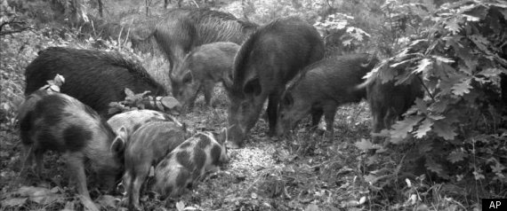
       This past Saturday, October 29, 2011, at 5:00 in the afternoon, I heard a terrible noise in the dry leaves getting close to my tree stand.  I immediately stood up, grabbed my bow, and waited.  I kept looking in the direction of the noise as the sound was getting louder and louder.  Finally some 60 yards from my stand, I saw five big black hogs walking abreast feeding through the oak timber gathering nuts as they were moving through the woods.  Behind the first line of hogs, a very large herd of animals, more than I could count without getting them mixed up, was moving just to the west of my stand.  These wild hogs took several minutes to walk past my position just out of bow range.  I estimated the herd contained 30 or more animals.  This was the second largest group of hogs I have witnessed in Bankhead Forest.  The largest number I saw several years ago in one group was in excess of 40 or more animals near Cedar Ridge on the northwest part of the forest south of Mt. Hope.

Feral Swine       I have hunted the management area and forest property east of highway 33 for several years and had no idea that the animals had increased their numbers to such an extent into this part of the forest as was evidenced this week with the extremely large herd I observed.  Over the last few years, hogs have expanded their territory to include the entire northern portion of William B. Bankhead National Forest in Lawrence County.  They have spread from the Morgan County line to the east all the way to the Franklin County line to the west.  These animals are probably here to stay and it appears that not only their range but also their population is increasing throughout north Alabama.         The origin of the wild hogs in Bankhead Forest is not clear but it is obvious that hogs have been in this area since the early settler days.  Even when domesticated hogs are allowed to range free, they are noted as being one the quickest domestic animals to revert to their wild nature and become feral pigs.  The first hogs I saw in Bankhead was prior to Turkey Foot Station game warden house and hunters camp building west of Sipsey River on the Cranal Road being torn down.  It was probably 30 years ago late one afternoon that I was hunting a honey suckle thicket behind the old hunters camp building at Turkey Foot Station when two feral pigs that weighed approximately 50 pounds each walked down an old log road past my stand.  I remember thinking that someone's pigs must have escaped from their pens; however, these pigs were some five miles from the nearest house.  Even though the hogs were in the middle of the forest, I had no though of shooting someone's pigs.  Today, I encourage all hunters to kill ever hog you see in the forest.        Hogs are some of the most environmentally destructive animals that roam the hills and valleys of our woodlands.  A group of wild hogs can root up an entire mountainside in search of things to eat.  In the last few years in the upper West Flint Creek, Capsey Creek, and Brushy Creek regions, I saw where hogs had plowed up large areas of the forest floor looking for roots, grubs, and small animals to eat.  They will eat just about any living organisms that are easily accessible from snakes to wildflowers and everything in between.  They can cause erosion problems, destroy sensitive rare wild flowers and plants, and are in direct competition with deer, turkey, and other wildlife that depend on the mast crop.  In addition, hogs are becoming a problem for farmers by destroying their crops and damaging their property.         Wild hogs are one of the most prolific big game animals having as many as 12 or more young per single litter.  The exact size of their population in Bankhead Forest is not known, but you can be sure that their numbers are increasing throughout our area, and their reproductive potential has a tendency for a rapid increase or explosive growth in their numbers.  Probably their worst predator is the coyotes that will prey on their young and an occasional bobcat.  Other than these carnivores, the only way to effectively control their population without spending a lot of money trapping is by hunting.  Under normal hunting pressure, wild hogs seem to be able to maintain and even increase the number of individuals; however, the liberal hunting season seems to be the only factor that is limiting their population explosion in the Bankhead Forest. Even though hunters are killing hogs year around on general forest service property outside the wildlife management area, wild hogs are going to be very difficult to control and remove from all the farmlands surrounding the forest.  If the trend continues, hogs will probably spread throughout the entire county over the next several years creating a lot of destruction to crops.  At present, I do not want to sound an alarm because our local hunters will not hesitate to put a ham on the dinner table if their sights line up with a wild hog in the Warrior Mountains.

Thursday, November 3, 2011

Sequoyah's Father-Traitor and Patriot

Traitor and Patriot


       Sequoyah or George Gist, born about 1776, was the son of Colonel Nathaniel Gist and Wurteh Watts.  Wurteh Watts' mother was also known as Wurteh, the daughter of Great Eagle and granddaughter of Moytoy.  Wurteh married John Watts and was the sister to Red Bird, Old Tassel, Standing Turkey, Doublehead, Pumpkin Boy, Sequechee, Nancy, WarHatchy, and Ocuma (Melton).


       George Gist's father was initially a trader to the Cherokees and later worked with the British agents Stewart and Cameron.  At the beginning of the Revolutionary War, Nathaniel was living among the Cherokees on the Little Tennessee River in present-day Monroe County, Tennessee.  He was probably married to Wurteh Watts because he was considered by Old Tassel to be a part of his immediate family. Therefore, after the signing of the Declaration of Independence on July 4, 1776, and after the beginning of the Chickamauga War upon agreement known as the Treaty of Sycamore Shoals in 1775, Nathaniel Gist would have been considered a traitor to the newly established United States of America, since America was at war with both the British and Cherokees.


       Wurteh Watts’ fourth husband, Colonel Nathaniel Gist, was born October 15, 1733 in Baltimore, Maryland.  Nathaniel Gist died at about 80 years old in Kentucky as reported by Samuel C. Williams (1937).  “On his Kentucky (land) grant Colonel Gist established his home, "Canewood," which was to become noted for the beauty of its embellishment and for its hospitality. He died there about the close of the War of 1812.”  Nathaniel was the son of Christopher Gist and Sarah Howard and was of Scots-Irish lineage.

Sequoyah


      Nathaniel Gist (son of Christopher Gist) first appeared among the Cherokees as a messenger of Governor Dinwiddie in 1775.  Following the French and Indian War, he formed a trading partnership with Richard Pearis and lived in the Cherokee Country for several years.  During that time, he took as his wife, Wurteh…and became the father of Sequoyah (Brown, 1938).


       …by a Kentucky family it is claimed…Sequoyah’s father was Nathaniel Gist, son of the scout (Christopher Gist) who accompanied (George) Washington on his memorable excursion to the Ohio.  As the story goes, Nathaniel Gist was captured by the Cherokee at Braddock’s defeat (1755) and remained a prisoner with them for six years, during which time he became the father of Sequoyah.  On his return to civilization, he married a white woman in Virginia, by whom he had other children, and afterward remove to Kentucky, where Sequoyah, then a Baptist preacher, frequently visited them and was always recognized by the family as his son (Mooney, 1900).


       Other historical documents indicate that Nathaniel Gist was actually an agent serving under British Commander Cameron who was supplying the Cherokees with arms and ammunition to fight the white settlers and American soldiers.  The following was given by Samuel C. Williams (1937):


       Too, as we shall later see, in the following year Gist wrote to the Cherokees reminding them that he had on this occasion, in 1776, warned them, before they went to war against the whites, against the step…When, after the three contemporaneous attacks on the upper country settlers at Island Flats, on the Watauga and in Carter's valley, and in the latter part of the same year Colonel William Christian began his retaliatory campaign against the Cherokees, his instructions from Governor Patrick Henry were to insist upon the Indians "giving up to justice all persons amongst them who had been concerned in bringing on the present war, particularly Stewart [Stuart], Cameron and (Nathaniel) Gist."


       When Christian, on the march towards the Cherokee towns, reached the French Broad River, (Nathaniel) Gist came in from the Indian side under a flag of truce to the camp of the colonel. He reported that 1,000 of the Cherokees from the Carolina side of the mountains had joined the Overhills, who would not give battle until the troops crossed the Little Tennessee. Christian wrote to Governor Henry (October 15, 1776) "I judge the flag was only an excuse for him to get with me. I believe he is sorry for what he has done. I did intend to put him in irons, but the manner of his coming I believe will prevent me. The officers tell me that the camp is in great confusion about him; some think that there are many favorable circumstances attending him; many are for killing him—of the last the greatest part. I spoke but little to him and don't know whether he wants to go back or not."


       Two of the soldiers under Colonel Christian left accounts of this incident. Benjamin Sharp stated that the border men "were so exasperated at him that almost every one that mentioned his name would threaten his life, yet Christian conveyed him through the settlements unmolested, and he went to the headquarters of Washington, where I presume the former friendship was renewed. He became a zealous Whig." John Redd stated that "when Gist first came in to Christian he was viewed in a very suspicious light; he was thought to be a spy. But the prejudice against him soon wore off and he became very popular."


       Gist went to Virginia and promptly laid a memorial before the governor and the council of state. The order entered by the council, Dec. 17, 1776, as is follows:


       "Captain Nathaniel Gist having presented a memorial to the Governor lamenting the suspicions which he fell under with several of his countrymen, as having acted an inimical part against America by aiding and abetting the Cherokees in their late hostile conduct and desiring his excellency and the council would make inquiry into the same, as a preparatory step either to his acquittal or consign punishment, the board accordingly considered the several depositions transmitted by Colonel Christian to the governor and which had been laid before the general assembly, and moreover examined Colonel William Russell, Major Evan Shelby and Isaac Thomas, upon oath; and, upon the whole matter are of opinion that Captain Gist is a friend of his country and was acting in that character most effectually when he was suspected of encouraging the Indian hostilities."


       It no doubt gratified General (George) Washington to have the record of an old friend thus cleared; and on Jan. 11, 1777, Gist was appointed a colonel of a regiment in the continental line. The newly-made colonel was sent south by Washington to use his influence in bringing the Cherokees into the promised treaty at Fort Patrick Henry, Long Island. Arriving at the island on March 28, Gist sent by an Indian messenger a talk to the chiefs, a copy of which is to be found in the Library of Congress, Manuscript Division (Williams, 1937).


       Therefore, Gist was living among the Cherokees at the time that George Gist was conceived and probably born in 1776.  Most all historical documents agree that Nathaniel Gist was the father of Sequoyah and even some important Cherokee leaders of the time as seen in the following: 


       The Tassel (Kahn-yah-tah-hee), uncle of the Indian consort of Gist, replied:” Here is my friend and brother (pointing to Colonel Gist) whom I look upon as one of my own people. He is going to leave me and travel into a far country, but I hope he'll return. Here is one of my people, the Pigeon, that will accompany him, but I do not know of many more that will. He was once over the great water where he could not see which way he was going; but this journey will be all by land and he will think nothing of the fatigue."


       At the end of the treaty negotiated at Fort Patrick Henry in 1777, above the signatures, appears this "memorandum before signing":  "The Tassel yesterday objected against giving up the Great [Long] Island opposite to Fort Henry to any person or country whatever except Colonel Gist, for whom and themselves it was reserved by the Cherokees. The Raven did the same this day in behalf of the Indians and desired that Colonel Gist sit down upon it when he pleased, as it belongs to him, and them, to hold good talks on."  Colonel Gist aided while on the treaty ground in celebrating the first July 4 anniversary ever held in Tennessee (Williams 1937).


       Wurteh Watts and Colonel Nathaniel Gist had one son George Gist, also known as Sequoyah, who was three eighths Cherokee and five eighths Scots-Irish. 


       George Gist (Sequoyah) was born about 1776 just outside Fort Loudon in Tuskegee Village on the Little Tennessee River, in Monroe County, Tennessee.  He married Sally Waters and they had the following children:  1) Teesey, 2) George II, 3) Polly, and 4) Richard.  Sequoyah also married Utiyu (Uckteeyah) Langley and they had Eyagu, Oolootsa, and Guneki.  Sequoyah died in Mexico in the summer of 1842 looking for lost Cherokees.


       Read more about Doublehead's family in my soon to be released book-Doublehead: Last Chickamauga Cherokee Chief.  Be sure to become a member of my blog by clicking on "Join This Site".

Sunday, October 30, 2011

Celtic-Indians of Warrior Mountains/Freedom Hills

Celtic-Indians

       Between the 1700's and early1800's, many of the Southeastern Indians intermingled by marriage with Celtic traders of Irish and Scot-Irish ancestry and became mixed blood members of the Indian nations.  The Celtic traders were contracted by the English subjects loyal to the Crown because a proclamation of 1736 prohibited the English from crossing the Appalachians; therefore, Scots-Irish traders came in contact with Indian people and married their maidens. By the early 1800's, these mixed bloods became the leaders of the Creek, Chickasaw, and Cherokee tribes of the Southeast.  Alexander McGillivary  became Chief of the Creek Nation.  John Watts, Jr. and John Ross became Chiefs of the Cherokee Nation; and, George and Levi Colbert became the Chiefs of the Chickasaw Nation.  


       Many of these mixed Celtic-Indian people were eventually forced into hiding or denial of their Indian ancestry because of their fear of removal to the west by the United States Government.  The newly established southern states, still in their infancy in the early 1800’s, refused the right of the Cherokee, Creek, or Chickasaw to establish Indian nations within the newly recognized sovereign states of Alabama, Georgia, Mississippi, and Tennessee.

       The “Documents on United States Indian Policy” written by Francis P. Prucha gives a quote on December 8, 1829, from President Andrew Jackson as, “the Southern tribes, having mingled much with the whites and made some progress in the arts of civilized life, have lately attempted to erect an independent government within the limits of Georgia and Alabama.  These States, claiming to be the only sovereigns within their territories, extended their laws over the Indians, which induced the latter to call upon the United States for protections.”  Jackson went on the say, “It seems to me visionary to suppose that in this state of things claims can be allowed on tracts of country on which they have neither dwelt nor made improvements, merely because they have seen them from the mountain or passed them in the chase.”  Jackson, the great Indian fighter of the Southeast, believed in the spoils system, “To the victor belongs the spoils of war.”  After the Treaty of Fort Jackson in 1814 and on November 22, 1816, Jackson laid claim to the Celtic-Cherokee Indian farmland at Melton’s Bluff in Lawrence County, Alabama.  The land Jackson took had been farmed by Irishman John Melton who had married Doublehead's youngest sister Ocuma.  The son of John and Ocuma, David Melton signed the deed with Jackson.  As he took from the local Celtic-Indian people at Melton’s Bluff prior to the time that any legal land claims could be made, Jackson had no reservations about eliminating all Indian lands east of the Mississippi River after becoming President of the United States in 1828.


       During the turbulent times in the early history of the Southeastern United States, Celtic people, who have always been somewhat rebellious freedom seekers, migrated into the Indian homelands, mingled with the native people, and married into their tribes.  As the Federal Government forced the Indian removal issue during the 1830’s under Jackson’s administration, mixed-blood Celtic-Indians began moving from the Cherokee Nation in Alabama, the Carolinas, Georgia, and Tennessee into the Warrior Mountains or Freedom Hills of northern Alabama.  The hills and mountains provided isolation and protection as long as they denied their Indian backgrounds.  The Celtic-Indians, who were of dark complexion, would many times claim to be Black Dutch or Black Irish and deny their rightful Indian descent in order to stay in their aboriginal lands.

       Those who question the idea of intermarriage of Celtic and Indian people, who settled primarily on the poor isolated lands found in the Warrior Mountains of north Alabama as well as other isolated areas, are merely misinformed.  After looking into their eyes and examining the features of those who make efforts to reclaim links to their Indian past, many common threads appear which not only strengthen but confirm that the vast majority of these people are truly Celtic-Indians afflicted with over 150 years of denial.  Isolationism and intermarriage forced their complexions fairer through the genetic sieve of the Scots-Irish which transcends nearly two centuries.  However, from within their hearts they speak with a straight tongue of their Indian ancestors who survived in the Warrior Mountains or Freedom Hills of North Alabama.


       One of the most common characteristics of the true Warrior Mountains Celtic-Indians is the direct line of descent from the Cherokee, Chickasaw, or Creek originating around the 1830’s just prior to the Great Removal.  Another common occurrence was the intermarriage within family units, where cousins married cousins, sisters of one family married brothers of another family, two different families intermarried over several years, and children from the same mother and different fathers took the mother’s last name.  One would be amazed at the number of mixed Indian people having the same great-grandparents on two sides of their family.  An original Warrior Mountains Celtic-Indian, who is at least a quarter blood Indian, will many times have the same great-grandparents on more than one side of their family.  Another common thread is the migration of their Celtic ancestors from the Carolinas and Georgia to Tennessee and Alabama.  Intermarriage between Celtic and Indian people most often occurred in the Carolinas, East Tennessee, North Georgia, and Northeast Alabama which made up the Cherokee Nation until 1838.  The remnants of the Warrior Mountains Celtic-Indian mixed-bloods still survive in the Southeastern United States under common Celtic family names.


       A famous mixed-blood Cherokee by the name of John Ridge stated in 1832,"Cherokee blood, if not destroyed,will win its course in beings of fair complexions, who will read that their ancestors became civilized under the frowns of misfortune, and the causes of their enemies."    Today, remnants of the Celtic-Indian people of the Warrior Mountains or Freedom Hills of north Alabama have read about their mixed ancestors in this blog.

Wednesday, October 26, 2011

Killer Coyotes Eat Deer

Killer Coyotes


       Early yesterday morning October 25, 2011, I could hardly believe my eyes when I saw the remains of a buck that probably weighed close to 175 pounds.  At 5:30 in the afternoon, I shot the buck with my bow at some 25 yards and was not exactly certain where the arrow had hid the deer; therefore, the outdoors shows' theme raced through my mind, "When in doubt, back out".  I did what I thought was a correct response and backed out since it was dark when I climbed out of my tree; however, to my disappointment a pack of coyotes had found my deer and left only the head, horns, hoofs, part of the hide, and a little of the backbone.  There was not enough meat left on that buck to make a single hamburger.  Evidently, a pack of coyotes can put away a lot of meat in some 12 hours.  My shot must have been excellent since the deer ran about 50 yards into a pine thicket before dying.  My new theme is, "When in doubt, check it out".  A blind man could have followed that blood trail which was two feet wide.

       A pack of coyotes can put a hurt on a deer herd, especially young fawns.  A recent outdoor magazine stated that some 80% of the fawn mortality on the nuclear facility on the Savannah River was due to coyotes.   The study also predicted a decline in the population of the deer herd in the southeast due to the increase in the coyote population.  There is no doubt that the population of coyotes is increasing in this area each year.  Folks around here complain of the increased frequency of being awakened at night by the howling of a pack of coyotes.

       While on the Northwest Road in Bankhead Forest, two veteran runners begin their strides along the incline between the Mountain Springs Road and Borden Creek.  As the two runners raced along, a nearby agonizing bleat caught their attention.  Immediately the pair of runners stopped to examine the source of the cries and some 50 yards from their position, an adult doe was frantically running around the hillside.  Between the doe and the runners, a huge coyote was making the final killing bites on a small spotted fawn.  The coyote picked up the dying fawn in its jaws and trotted off through the woods. The runners said you could plainly see the fawn's legs dangling on either side of the big coyote's body.

       Some years back, a friend and I were scouting for deer sign when we ran across a recent deer kill.  As we approached the animal, a bunch of coyotes took off through the woods.  Fresh blood and muddy water indicated the deer had just been killed and only a small portion had been eaten by the predators.  Another eye witness account comes from a Bankhead land owner who said a group of coyotes began making a large disturbance in his pasture not far from his house.  The next morning he investigated to find the remains of an adult deer that had been about totally consume by the predators.  Coyotes have become the primary predators of adult whitetails in north Alabama and across the Southeastern United States.  They may be one of the primary reasons the Bankhead and other north Alabama deer herds have difficulty in maintaining larger deer populations.

       According to the Alabama Fur Takers Association, "Alabama trappers first reported catches of coyotes in the early 1970's".  Since that time, the range and population of coyotes have spread across the entire State of Alabama with their increasing numbers causing trouble for other prey species such as the rabbit, quail, and even foxes.  The decline in the number of foxes could be due in part to the competition for habitat and the ability of coyotes to kill foxes.  Some trappers report that coyotes literally destroy the foxes caught in their traps.

       Some folks believe that the coyotes migrated from the west and may have interbred with the red wolves that used to be found in the Southeastern United States.  The larger size of eastern coyotes may be due to genetics, cross-breeding, or may simply be due to the abundance of the food supply, climate, and habitat.  Whatever the reason of the eastern coyote's larger size and widespread dominance in northern Alabama, everyone agrees that the killer coyotes of the Warrior Mountains has become a dominate predator of many species of wildlife as well as goats, sheep, calves, and pets.

       I know from personal experience that a pack of coyotes can eat an entire deer in one setting; therefore, from this point on, I intend to try to kill every coyote that gives me the opportunity.  However, I know on full moon nights that the howl and yelp of the killer coyotes can be heard from one end of the Warrior Mountains to the other.  I know that the wily coyote is here to stay!

Saturday, October 22, 2011

Warrior Mountains

Interesting Places of the Warrior Mountains

Sipsey Wilderness

       Sipsey Wilderness is found in the southwestern portion of Lawrence County, Alabama.  Many people enjoy the beauty of the Sipsey Wilderness Area of Bankhead Forest that lies in the heart of the Warrior Mountains.  Sipsey River Picnic Grounds are located on Sipsey River near the Cranal Road, the south border of the wilderness.  You can not only hike in the wilderness, but also drive along Highway 33 and the Cranal Road to enjoy the fall colors and splendors of the Sipsey Wilderness.  Sightseeing, hiking, canoeing, and horseback riding are only a few of the many outdoor recreational activities available to visitors from all over the Southeastern United States.  The Sipsey Wilderness is the place for those who want to get away from modern conveniences without the sound of traffic, telephones, and TV’s, but instead listening to the songs of warblers, the hammering beaks of woodpeckers, the hoot of the great horned owl, the howl of a lone coyote, and the sound of water running over numerous falls crashing on rocks and boulders of the many streams flowing through this portion of the Warrior Mountains.  Avid outdoors men and women cherish the stimulating sounds, sights, and smells that only mother nature can provide to those who visit the Sipsey Wilderness.

       The U.S. Forest Service has designated and established trails for hiking, horseback riding, and horse or mule drawn wagons.  These trails and roads provide access to secluded sandstone cliffs, wonderful waterfalls, fantastic fall foliage, beautiful wildflowers, and tremendous trees.  Designated hiking trails begin at Borden Creek Bridge on the Bunyan Hill Road, Sipsey River Picnic Area, and at Thompson Creek Bridge on the Northwest Road.  A hiker can spend a few hours or a few days hiking the trail systems in Sipsey Wilderness.  McDougal Hunter’s Camp is a campground for those hunting or hiking in the area.  A system of horse trails begins at Owl Creek Horse Camp and contain many miles of connected riding loops.  The new addition to Sipsey Wilderness can be used by horse or mule drawn wagons.  The wilderness access to wagons could provide rides for young, old, and disabled individuals through the most scenic portion of our Warrior Mountains.

       In addition to various types of trails and roads in the Sipsey Wilderness Area, primitive wilderness camping is available to those who really want to get away without driving for hours.  Two sites which I would strongly recommend for wilderness camping is Bee Branch and Ship Rock which are isolated areas with great sandstone bluffs and shelters located on either side of the canyons.

McDowell Cove

       McDowell Cove of Bankhead Forest is located primarily in Section 4 Township 8 South and Range 8 West.  McDowell Cove is on the upper drainages of Flanagin Creek and is one of the most beautiful canyons in the Warrior Mountains.  The Cove lies between Mountain Springs Road on the eastern ridge, Gum Pond Road located on the western ridge, and the Ridge road on the northern ridge.  In the center of McDowell Cove, an Indian mound is found in the front yard of Jack McDowell’s old log house.  The flat level top of the mound actually lies immediately east of the dog trot style log cabin.  The sides of the mound only rise some four to five feet at the highest point.  Around the mound, numerous flakes of flint can be found.  Throughout McDowell Cove, flint provides evidence of long term occupation of the cove by Indian inhabitants.

       The area has been known as Wallis Cove, Wilkerson Cove, and after many of the other families that inhabited the area in the past; however, since Jack McDowell was the first Forest Ranger of Bankhead and one of the last to make the Cove his home, the area is widely accepted as being McDowell Cove.  Wallis Cemetery, named after some of the Cove’s first residents, contains the graves of four Civil War soldiers.  Two old houses still stand in the flat valley – Jack McDowell’s home and the Wilkerson home.  The old Sally Ann House was sold to Mr. Norman Tidwell from Winston County and moved during 1993.  Open pasture or farm land located in the Cove which is privately owned.

Bee Branch Canyon

       Bee Branch of the Sipsey Wilderness Area is located primarily in Section 26 of Township 8 South, Range 9 West.  Bee Branch is a deep canyon located east of Sipsey River.  The area is probably the most primeval site in the Warrior Mountains.  Most of the canyon was protected by the U.S. Forest Service as early as 1919.  Bee Branch is a forked canyon with seasonal and beautiful waterfalls in each fork.  The Bee Branch Falls plunge from 50 feet above the canyon floor.  Both forks are virtually box canyons forming a small creek that flows into Sipsey River.  The eastern fork of the canyon features the largest yellow poplar in the Southeastern United States.  The whole canyon is a botanical garden of a virgin gorge in the Warrior Mountains.

Tar Springs Hollow

       Located in the upper portion of Capsey Creek, once known as Capp’s Creek, is a place not found elsewhere in William B. Bankhead National Forest.  The creek begins at Cave Springs on Highway 41 and on the Leola Road at Basham Shelter and Spring.  The area, not noted for the two head water springs, is unique because of the two springs downstream in the middle of the big hollow.  These unusual downstream springs contained tar and the reason the site is known as Tar Springs Hollow.

       Capsey Creek is a tributary to Brushy Creek which empties its waters into Sipsey River on Smith Lake.  The Tar Springs Hollow on Capsey Creek contains two mineral tar springs which are located about once quarter mile apart in the southwest ¼ of Section 26, Township 8 South, and Range 6 West.  According to the Alabama Geological Survey as reported by geologist Jonathan Hunter, “These springs years ago were places of a resort for the afflicted who drank their waters and swallowed their tar or maltha, made into pills, and supposed that they were greatly benefitted thereby.  The hotel and cottages for the accommodations of the visitors to these springs are said to have stood on the hill just south of this lower spring.  Both of these springs, however, have been spoiled by blasting them for asphaltum.”  The article also indicated that barrels of tar were collected in holes made in the floor of the springs and shipped off.  In addition to the Tar Springs, oil wells were drilled in 1865 and 1867 that were between 700 and 800 feet deep.  The geological survey reports that Jonathan Watson probably drilled and got oil out of the wells in Tar Springs Hollow.

       Tar Springs Hollow Road was one route many settlers and visitors took to the Tar Springs Resort.  The early road lead from Melton’s Bluff to Oakville, then to Poplar Log Cove where the road forked.  The eastern fork was the main route and was the Black Warriors' Path or Mitchell Trace.  The south fork became known as the Tar Springs Hollow Road or Double Springs Road and traveled south up Wiggins Hollow.  The Double Springs Road crossed the High Town Path east of Center Church and passed down a long ridge into Tar Springs Hollow.

       From the 1800’s through the early 1900’s, prior to the establishment of  the national forest, many people lived in the area of Tar Springs Hollow.  Cave Springs Cemetery and Center Cemetery contain the remains of many who called the Tar Springs Hollow area home.  It appears from examinations of the tombstones in Cave Springs and Center Cemetery, that many of the people were descendants of the Creek and Cherokee Indians, the earlier inhabitants of the area.  Many of the family names of those who presently compose the Lawrence County Indian population are found in the old cemeteries.  The family names at Center Cemetery include Osborn, Smith, Williams, McVay, Hampton, Jackson, Steele, Holley, Looney, Wood, Eddy, Asherbranner, Poole, Burnett, Hogan, Rooks, Kelsoe, Johnson, Cooper, and many others.  These family names still persist in the southeastern part of Lawrence County.  


       In the area of Tar Springs, the forest seems eternal except for the occasional timber harvest activity.  In the late evening as the eerie sounds of a screech owl were emerging from the forest, it was hard to imagine how the area might have looked when the hotel and cottages within the rugged canyon were alive with people seeking the healing powers of the Tar Springs in the heart of the Warrior Mountains.

Poplar Log Cove

       Poplar Log Cove of the Warrior Mountains is located primarily in Section 10 of Township 8 South and Range 6 West.  Poplar Log Cove is on the upper portion of the West Fork of Flint Creek in Lawrence County’s northeastern portion of Bankhead Forest.  Black Warriors’ Path traversed through the Cove and passed by the Poplar Log Cove Spring which forms the headwaters of West Flint Creek.  Based on archaeological evidence, Poplar Log Cove was utilized by Indian people as early as the Paleo Period.  A Paleo scarper and Decatur Point were found and identified near the center of the Cove.  Poplar Log Cove was settled in the early 1800’s by Indian mixed-bloods and white people.  The Cove was flat with broad fertile valleys which were farmed in patches of cotton and corn.  Today, most of Poplar Log Cove is privately owned but remains one of the most beautiful valleys of the Warrior Mountains.
  
Indian Tomb Hollow

       Indian Tomb Hollow is located primarily in Section 2 Township 8 South, Range 7 West on the northern edge of William B. Bankhead National Forest.  In the distant hollows of Indian Tomb, the wood hen can be heard as the evening sun sinks behind the bluffs.  Three gracious waterfalls of the southwest fork echo eternal sounds that formed the sandstone canyon containing vertical walls reaching to the sky.  Looking down the canyon toward the northeast sandstone bluffs on either side of the canyon causes one to be in awe of the area because of its beauty.

       Early settlers and Indian mixed-bloods settled to the north and west of the hollow’s southwestern fork.  Several folks lived for a while in the old High House located on a small knoll at the mouth of Indian Tomb.  Families of the Warrior Mountains would enter the hollow from Chestnut Ridge, Beulah, and High House Hill not only to view and enjoy the beauty of the area, but to dig roots, herbs, and hunt.  It was in this same tradition that I was first introduced by my granddad Arthur Wilburn, to the mysterious but beautiful Indian Tomb Hollow.

       Mr. G. H. Melson tells of experiences he had as a small boy in Indian Tomb Hollow and was a wealth of information concerning an Indian fight occurring near the mouth of the famous canyon.  He told of his father working on the old plantation and passing down stories through many generations about the Indians of the area, the black slave cemetery, and the early settlers who called the area home.

       Over many years, the Gillespie family has traditionally been drawn to Indian Tomb.  Not only does the family consider the area a sacred Indian burial site, but their ancestor, James Richard Gillespie, a veteran of the Creek Indian War, is buried in the Gillespie Cemetery.  In addition, Gillespie Spring and Gillespie Creek, which runs through Indian Tomb Hollow, are named after the Gillespie Family of Lawrence County.  The ancient beech trees of Indian Tomb are a record of family traditions which have spanned over 200 years of time.  From early Indian drawings and settler names, the beeches of Indian Tomb bear record of visitation.  The markings also indicate that much of the time spent in Indian Tomb was recorded in the numerous beech carvings located throughout the canyon.  In addition, the Indian Marker Tree in Indian Tomb Hollow is a symbol considered sacred by the descendants of those who once roamed the beautiful valley.

       A story called the “Battle of Indian Tomb Hollow” or “Ittaloknak” was originally printed in The Moulton Democrat in November 1856. The articles compose a beautiful love story that describes a fierce fight in Indian Tomb between the Creek and Chickasaw inhabitants of the Warrior Mountains.

Narrows Ridge

       Narrow Ridge is located in Bankhead Forest in Section 21 of Township 8 South and Range 8 West.  While walking south on a ridge from the Northwest Road, suddenly a high narrow strip of land emerges between two beautiful old growth hardwood valleys.  The valley to the east was the Borden Creek Canyon and the valley to the west was the Flanagin Creek Canyon.  The old settler road along the top of the ridge continued along the slender natural bridge of sandstone rock connecting the two mountaintop ridges which divided the beautiful creek bottoms.  To either side of the old road were the edges of bluffs which rose some 40 to 60 feet above the two hardwood valleys.  The narrow ridge runs in a north-south direction for approximately 100 yards narrowing to as little as some 12 feet wide.  The unique and beautiful ridge is known to most local people as the “Narrows Ridge.”  Narrows Ridge is now in the Sipsey Addition to the Wilderness Area which will provide protection for the beautiful hardwood valleys on either side of this natural ridge.

       It appears that early settlers in the area south of Narrows Ridge were also forced to use the connecting strip of rock to get to their valley farms and crops located near the forks of Borden and Flanagin Creeks.  The Henderson Family and Parker Family, whose descendants still live in the Moulton area, have roots in the Borden Creek portion of the area.  The Gooder Walker family had crops and farm land along the western portion of the area along lower Flanagin Creek.  The road leading to Narrows Ridge is about ¼ mile east of the Mountain Springs Road.  The log road runs south from the Northwest Road’s highest point between Borden Creek and Flanagin Creek.  About ½ mile west of Borden Creek, the log road turns south and runs ¾ mile prior to reaching Narrows Ridge.  Narrows Ridge is a unique but beautiful spot in the Warrior Mountains.

King Cove

       King Cove is located in Township 8 South, Range 9 West in Sections 22 and 27 of the southwestern portion of Lawrence County.  King Cove lies adjacent to the forks of Hubbard and Thompson Creeks which is the beginning of Sipsey River in the western portion of Bankhead Forest.  The King Cove extends up Thompson Creek to the forks of Tedford and Mattox (Thompson).  Ship rock is found at the southern end of King Cove and is just east of the forks of Hubbard and Thompson.  King Cove shows evidence of early Indian habitation.  Mortar Rock, located to the north across the creek from Ship Rock, contains five mortar holes and a huge nutting stone used by early Indian people.  Local folklore tells of numerous arrowheads and spear points picked up in the old creek bottom fields.

Parker Cove

       Parker Cove is located in Section 30 of Township 7 South and Range 7 West and is named from the Parker family who settled the cove long ago.  Parker Cove forms the headwater streams of Elam Creek on the north-central edge of Bankhead Forest.  The cove still contains three old log houses that were used over 100 years ago.  When going south on Highway 33, the main entrance to Parker Cove is along the first steep winding road turning east off of Wren Mountain.  The deep cove is visible east of the Wren Mountain portion of the Wilderness Parkway which runs through the center of the Warrior Mountains.

Blankenship Cove

       The lower portion of Blankenship Cove is still an active farming site and is located primarily in Section 2 of Township 8 South and Range 8 West on the upper portion of Borden Creek.  The cove was originally called Borden Cove, settled by the family of Christopher Borden.  The upper portion of Blankenship Cove extends through the northeast part of Sections 34 and 35 of Township 7 South and Range 8 West.  Some of the Borden Family originally settled along portions of the cove adjacent to Borden Creek.  The cove is presently owned by Glenn Whisenant, who bought the property from the heirs of his Granddaddy Willis Blankenship.  Two areas of the Blankenship Cove were known as the upper place and the lower place.  Willis Blankenship lived on the lower place.  Ownership of land in the early days of settlement gave priority in naming some of the Coves of Bankhead.  Many of the coves still found in Bankhead are beautiful isolated islands of open land nestled in the heart of the Warrior Mountains.

Ship Rock

       Ship Rock is located in the Sipsey Wilderness Area in Section 27 of Township 8 South and Range 9 West.  The large rock is located some 200 yards east of the forks of Hubbard and Thompson Creeks in the heart of the Sipsey Wilderness.  The site is known as Ship Rock, Herron Point, Boat Rock, Needle’s Eye, or the Windows.  The following text is a descriptive but symbolic version of the Ship Rock of Sipsey.  The mighty Ship Rock of the Black Warrior is sailing east dragging the mountains and canyons of unspeakable beauty through the universe.  In front of her awesome sandstone bow is the Tugboat Rock of the forest leading the way and breaking the bonds of time to allow the Ship Rock to meet her destiny beyond the knowledge of humankind.  The Tugboat Rock is always at her bow never allowing her voyage to be slowed by the forces of time. Near the stern of Tugboat Rock is the Needle’s Eye which focuses the last easterly flowing rays caught from the westerly setting sun to provide the brief sailing light toward the east before darkness again dims the mighty ship’s journey.  Thousands of years ago, the forces of time blasted the hole called the Windows or Needle’s Eye at the stern of Tugboat Rock yet undaunted the little sandstone tug maintains a true course guiding the mighty Ship Rock through the earth’s celestial sphere.  

       Out of Hubbard Creek Canyon, and through the middle of King Cove, she sails leaving a deep botanical trough and solid standing waves of sandstone which begin to close at the falling waters of Parker, Quillan, and Kinlock.  The waterfalls of the Warrior Mountains send the melodious sound waves of the true wilderness lapping at her sides.  At the bow of Ship Rock, the crest rises high, creating vast depressions of beautiful valleys through which the Sipsey and Thompson waters flow.  Forever eastward toward the rising sun, dawns a new day for her forested sea.  She plows and pulls the high bluffs as she churns constantly through the land of a thousand waterfalls.  From the botanical gardens of the limestone valleys, to the hardwood ridges of the sandstone slopes, she has sailed from before the time of the dinosaurs toward eternity with the timeless canyons of the Warrior Mountains lashed firmly to her stern.

       Ship Rock has a great deck nearly 1,000 feet in length and over 100 feet wide.  Her bow is a sharp rising crest which rides high in the waves of the air reaching nearly 60 feet above first contact with her timbered and stony sea.  Her stern is broad with the great force of Mother Nature driving her through the mountainous sea, always leaving the beginning of Sipsey in her wake.  Her sides, adorned with big flowered trillium, Virginia bluebells, blue cohosh, and Dutchman’s breeches, rise some 50 feet to the mountain laurel and Virginia pine covered deck.  Ship Rock is a moment in time and a symbol of persistence before the age of the great reptilian dinosaurs, the age of the gigantic mammals, and the age of the red man who once inhabited her great forested seas.  No time, force, or age is her master, for God is her pilot and only he knows her true destiny.  As God spins the eternal swirl of the universe, Ship Rock holds steady while dragging the Warrior Mountains along with the rest of the world.  

       Where is the huge Ship Rock, the Tugboat Rock, and the Needle’s Eye?  These geologic wonders are woven into the fabric of Lawrence County’s Warrior Mountains.  The magnificent weaver left his Needle’s Eye as a guide for those who may think they are lost to the great ship and the little tug.  Now for directions: From the Byler road, turn east on the Northwest Road and go to the dead end at Thompson Creek Bridge.  Take the wilderness trail which turns south down the east side of the beautiful Thompson Creek Canyon.  You will hike about one and a half hours before you see a large hole in the face of the bluff just prior to reaching the forks of Thompson and Hubbard Creeks.  You have arrived at the Ship Rock of the Warrior Mountains.
  
Kinlock Rock Shelter

       Kinlock Rock Shelter is located in Section 31 of Township 8 South and Range 9 West.  The shelter is one of the largest of its kind with an overhang of sandstone rock some 250 feet wide, 30 to 100 feet deep, and 30 to 150 feet high.  The Indian shelter is a premier petroglyph site of prehistoric Indian occupation.  The sacred Indian shelter is still actively used by American Indians for ceremonies.  Presently, Kinlock Bluff Shelter could be nominated to the National Register of Historic Places.
                                                                                                                                                                                 
Pine Torch Church

       The oldest original log church in the State of Alabama is located on the Pine Torch Road in Bankhead Forest in Section 29 of Township 8 South and Range 7 West.  The old poplar log church was originally moved from Holmes Chapel, east of Brushy Lake, and reassembled.  The log church is 24 feet wide and 27 feet long, and is over 170 years old.  The first logs were hand hewed in the early 1820’s by the Holmes and Nicholson family (1820 Census of Lawrence County).  It was originally used for worship services by the congregation known as “Hard-shell Baptists.”  Blazing pine knots were used to light the church at night.  Thus, the church was named Pine Torch.  Dr. Charles Borden comments on the protection of the historic Pine Torch Church: “The Pine Torch Preservation Society, of which I am president, was formed in 1981 to preserve and perpetuate the historical attributes and uses of this memorable part of our heritage.”